
|
|
|||||||
| Image of the Day Images that will blow your mind - every day. [Blog] [RSS] [XML] |
|
|
Thread Tools | Rate Thread | Display Modes |
 09-16-2001, 12:22 PM
|
#1 |
|
Radical Centrist
Join Date: Jan 2001
Location: Cottage of Prussia
Posts: 31,423
|
9/16: Sea level change map
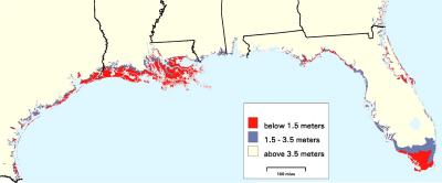 Perhaps you wanted something ELSE to worry about, if the possibility of war was not enough. Here is a bit of map of the Gulf Coast that would be extremely vulnerable to sea level rise due to global warming. This area would be the most affected in the US. Well maybe. You know that what somebody did was to get topographic maps of the US and color in the bits under 1.5 meters and then under 3.5 meters. The caveat they admit is right up front in their abstract: "In many cases, the results are as sensitive to uncertainty regarding geological processes as to the rate of sea level rise." Yah. Also, the EPA itself - the source for this - says that they think the next century's rise in sea level will be two feet. The red area shown is about 5 feet. (Note the mix of metric and non-metric is theirs, not mine...) Most of the red area is 1.3 metres above sea level and so a rise of two feet has little effect. They think the chance of sea level rising 1.5 meters in 60 years is 1%. *I* think if you are going to mix science and probability, you need to show your work. For more info: http://www.epa.gov/globalwarming/pub...aps/index.html |

|

|
| Currently Active Users Viewing This Thread: 1 (0 members and 1 guests) | |
| Thread Tools | |
| Display Modes | Rate This Thread |
|
|


 Threaded Mode