
|
|
|||||||
| Image of the Day Images that will blow your mind - every day. [Blog] [RSS] [XML] |
 |
|
|
Thread Tools | Rate Thread | Display Modes |
 04-21-2002, 06:25 PM
|
#1 |
|
Radical Centrist
Join Date: Jan 2001
Location: Cottage of Prussia
Posts: 31,423
|
4/21/2002 extra: Jenin satellite photos
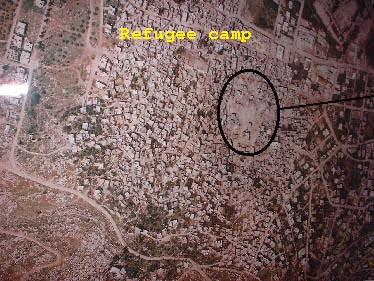
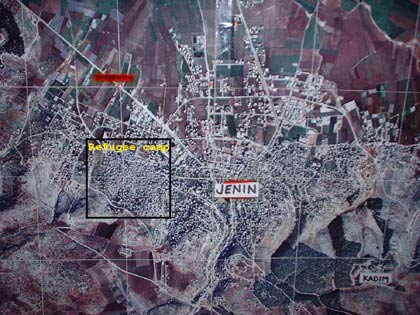
How massive was the Israeli invasion of Jenin? As individual news photos show numerous heart-breaking scenes of death and loss, the one thing we are lacking is proportion. What better to show proportion, then, but to show a satellite image of the place. In the first image, the circled area is the combat zone - 100 yards long.
|

|

|
|
04-21-2002, 09:21 PM
|
#2 |
|
Kinda New Member
Join Date: Apr 2002
Posts: 1
|
Orientation
It took me a while to figure out how these images are oriented relative to each other, so I thought I'd cache that info here for everyone else.
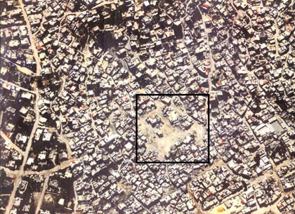
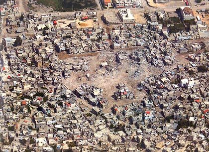
 The top of the first picture is almost aligned with the top of the last. You can see the grass and the corner of the intersection that occupies the top left of the last picture directly over the oval of the first picture. The second picture is nearly 180 degrees off, however. If you look at the third picture, just "campward" of the green grassy area you can see a yellowish dirt mound, and to its left a small bright red roof. These can be seen in the bottom right of the second image as a yellow blob at the edge, and a little red thing to its right. For reference inside the square itself, there's one little cubical building in the bottom center of the oval, the left center of the square and just above the two small red angled roofs in the third picture. Those two roofs themselves don't show up well in the other shots. With that I can get a vague idea of how the whole area is laid out... enough that I would guess the second shot was actually from BEFORE the destruction as there appear to be several buildings in it that are rubble in the others. (but maybe not) Hope all that helps everyone else. Oh, and hi: first time listener long time caller. Or whatever. :p
__________________
--- DeusExMachina |
|
|
|
|
04-22-2002, 02:18 AM
|
#3 |
|
neither here nor there
Join Date: Apr 2002
Posts: 179
|
Oh so that was why Israel kept the rescuers, paramedics and UN agencies out...so that they could get some good souvenir shots ´proving´ that there was no massacre before the photos would be ruined with pesky ambulances crawling over them.
|
|
|
|
|
04-22-2002, 02:36 PM
|
#4 |
|
Read? I only know how to write.
Join Date: Jan 2001
Posts: 11,933
|
It is rather difficult to believe that 13,000 people lived in what you see in that satellite photograph. However few buildings appear beyond the beltway road. I wonder if that is most of the town.
|
|
|
|
|
04-22-2002, 02:46 PM
|
#5 |
|
Radical Centrist
Join Date: Jan 2001
Location: Cottage of Prussia
Posts: 31,423
|
 There ya go. |
|
|
|
|
| Currently Active Users Viewing This Thread: 1 (0 members and 1 guests) | |
|
|


 Linear Mode

